TREE LIFE
October 2007
MASHONALAND CALENDAR
Botanic Garden Walk: Tom left for Europe a bit later than originally expected and we understand he will be back in October. We hope to resume our regular Botanic Garden walks in November.
Sunday, 21 October: A return visit to the Carlis’ farm on the Gardiner Road near Arcturus. We last visited it at a similar hot, dry time of the year in November 2005 and saw some interesting trees and herbs. The meeting time will be 9.30 a.m. Bring your chair and lunch.
Saturday, 27 October. Mark is not available this month to lead his normal 4th Saturday walk. However, it is intended to have an additional walk some time on a different date. Details will be sent to members by email and will be posted in the November Tree Life.
MATABELELAND CALENDAR
Please contact Jean Wiley or Gill Short for details of the next Matabeleland function.
WE HAVE A WINNER!
Our Attentive Reader Award goes to Eva Keller for spotting that we printed the Ngomakurira write-up in Tree Life for both August and September. Apologies for the duplication.
– Ed.
SOURCES OF SALT
This interesting extract is from notes made by Robin Hughes on Mana Pools National Park, dealing with the history of the area. I think it dates from the beginning of the 1970s, when he published another section on Chewore Safari Area as it is now.
Ian Riddell
From early as 1400 AD, when the Mkorekore moved into the Valley (or Gowa), salt has been the primary motive for the various tribal migrations and subsequent settlement in the area. In Guruuswa (or the Highveld, from whence came the forefathers of most of today’s resident population), salt was extremely scarce and that which was available, was of a poor quality and extracted from goat droppings by burning them and utilizing the resulting ash. In the Valley, salt of good quality was produced from two main sources: (1) that which was collected from the soil round highly mineralised springs and (2) that manufactured from the leaves and/or stems of various plants.
In the first instance, soil was collected (Chitope spring on the Chewore was a well-known and much-utilised spot) and placed in baskets, standing on legs some 2-3 feet above the ground. Water was then poured into the basket and in time would percolate through the mineralised soil, picking up various salts en route and drip through the bottom into a dish. This water was known as mutyora and was boiled away leaving a brown-coloured salt, of fairly poor quality known as chirungwenyi.
The second type of salt produced was of a much better quality and was the method most widely used and most kraal sites were to be found in areas where the necessary plants were available. The manufacturing method was similar in principle to that employed in the making of chirungwenyi and consisted of collecting the particular plants and letting the stems and leaves dry out thoroughly. This dry material was then burnt, the ash collected, put into an earthenware pot with small holes in the bottom and then water was added which dripped through into another pot. When boiled, this left a sediment fairly white in colour. It was apparently necessary to break this second pot in order to remove the salt which was of a rock-like consistency. I was given a piece by Chidoma which was made over twelve years ago and which is very pleasant to the taste. This piece of salt is now in the possession of the Warden i/c Mana Pools. This salt was manufactured from either one or a combination of the various types of plants listed below:

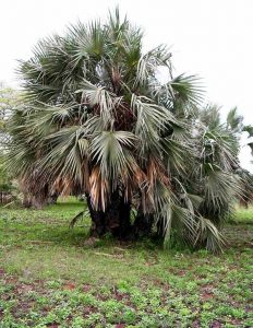
Hyphaene crinita. Photo:Bart Wursten. Source: Flora of Zimbabwe
Creeper – Chirungwenyi (plant variety) – Salvadora persica
Tree – Msembe – Hyphaene crinita (The plant used was only the mature full-grown tree standing about 70 feet tall and not the small, bushy type tree of the same species)
Bush – Guvira Monechma monechmoides
Both Salvadora and Hyphaene grow on a variety of soils and I have seen both on saline or sodic areas, Salvadora to a lesser extent; the palm is often dominant on these soils. Perhaps then, some salts are taken up and an interesting question is whether plants from these soils are used more than those on other soils?
Monechma is a bit of a mystery and I don’t know it at all (perhaps I have seen it and not known its name?) but hopefully Mark will be able to comment further. ]
Mark comments: I can’t add much to this debate. Monechma monechmoides appears to be a synonym of Monechma debile, which is a widespread annual herb which occurs (for example) around Harare. It seems unlikely that this is the species referred to – perhaps another species of Monechma is intended?
AN INTERESTING TREE

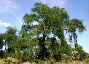
Faidherbia albida. Photo: Bart Wursten. Source: Flora of Zimbabwe
If you take the Enterprise Road, traveling out of Harare, pass Chisipite, go another 5 km or so, pass the Glen Helen turnoff, go another 100 meters, you will see on the right, growing about two meters from the edge of the tar, what appears to be a fine looking Acacia about 8 to 10 meters in height. So what, you might say – there are many finer-looking acacias in Harare. Don’t pass it by, stop and have a good look. For six months or so, I drove past this tree several times a week without paying it much attention, until one day in February 2007, I stopped and had a good look. It is not an Acacia, but a Faidherbia albida, growing a long way from its natural lowveld riverine or floodplain range.
How did it get there? The tree is definitely not planted. Possibly the seed fell off the back of a truck carrying firewood from the lowveld, or, more likely, cattle dung from transported cattle, which had been grazing in the lowveld. I know of two other albida propagated in a similar manner. One is growing in a cattle kraal at the back of Silveira House on the Arcturus Road, the other on a ranch, within a conservation area near Kwekwe, which was used as a holding pen for rhinos translocated from the Zambezi valley. An albida seed had germinated in the rhino dung and survived and grown into a tree.
When we first saw this tree in February, the leaves were grey-green. These old leaves were shed fully by April, and as I write on 26 May 2007, the tree is fully clad in a coat of new, pale-green leaves.
-Bernard Beekes
BRACHYSTEGIA GLAUCESCENS ON FLAT GROUND
In Tree Life No. 251, Tom covered the Brachystegia on the Botanic Garden Walk (7 November 2000) and mentioned that a form of Brachystegia glaucescens “occurs in the lowveld in deep sand. This appears to have smaller and fewer leaflets than the normal form, which is so reliably associated with rocky places.”
It is very interesting that glaucescens grows on flat to gently undulating ground in association with Colophospermum mopane and Julbernardia in dry deciduous woodland on the Umsweswe-Empress Mine-Gokwe Junction road a little southwest of Empress Mine and before the deeper red sands of the Mafungabusi Plateau; once you get closer to the junction they phase out. The altitude here is around 1000-1100 m. A few things need checking: the soils appear to be sandy, or perhaps sandy clays, since mopane grows there and the extent of the Brachystegia needs defining.
After more than 20 years of whizzing past, I have never actually stopped to check them out closely, and apart from mentioning this anomaly to the occasional passenger who would appreciate it, have only made ‘mental notes’. Whether they are a different form or not remains to be established but some of the trees are as big as the normal ones on rocky hillsides.
-Ian Riddell
THE RESURRECTION PLANT: MYROTHAMNUS FLABELLIFOLIUS
[An edited extract from an article in the September 2007 Veld & Flora. Ed.]Resurrection plants possess the ability to survive extreme drought by losing most of their water and existing in a seemingly dormant state for various lengths of time. After the summer rainfall, its seemingly dead and dried-up leaves return to a green, fully hydrated state and it continues to grow normally. One of southern Africa’s best-known resurrection plants is Myrothamnus flabellifolius.
Myrothamnus flabellifolius is a relatively large woody shrub, which is unusual as most of the other resurrection plants are either grasses or small herbaceous plants. It is also one of the more interesting species, as it appears to belong to a very ancient angiosperm lineage. Recent DNA evidence suggests that it split off from its closest relatives in the genus Gunnera over 100 million years ago. Ironically while M. flabellifolius is a small-leaved, woody shrub, its nearest relative in Africa is Gunnera perpensa, a large-leaved, aquatic plant commonly known as the water pumpkin! One might wonder how a small-leaved, desiccation-tolerant plant evolved from a large-leaved, aquatic ancestor. However, there is a rare and endemic Namibian aquatic resurrection plant Chamaegigas intrepidus (a member of the snapdragon or Scrophulariaceae family) that grows in rock pools that dry up periodically, which can survive desiccation and also tolerate being completely submerged.
Having evolved in the Late Cretaceous period during the evolution and radiation of most angiosperm families, M. flabellifolius possesses a unique combination of morphological and reproductive features which prevents a simple systematic classification and taxonomic placement. Currently M. flabellifolius resides in its own family, the Myrothamnaceae. It is possible that during the diversification of the angiosperms during the Cretaceous period, M. flabellifolius became saddled with a combination of morphological features not generally found in other angiosperm families. These features subsequently became modified and used to help the plant overcome the problems of extreme desiccation.
The first attempt at systematic classification of the various populations was attempted by Henning Weimarck, in 1936. He admitted that M. flabellifolius was a phenotypically very diverse species and that this proved difficult in delineating the various populations. He decided not to assign new species to the genus but rather to classify these variants as subspecies. He divided M. flabellifolius into three different subspecies, namely elongata, sensu stricto and robusta, based on morphological characteristics. Some of the subspecies did not correlate with their geographical location as elongata and sensu stricto occurred on both sides of the Kalahari Desert divide. Robusta occurred predominately in the northeast of Mozambique, although populations of sensu stricto were also present.
An initial study of phenolic and genetic variation amongst populations in South Africa and Namibia revealed that all the Namibian populations were similar to each other but completely distinct from populations collected in South Africa. DNA evidence suggested that the two populations diverged from each other around four million years ago. This may have been due to a combination of geographical (desert, inselbergs) and climatic (rainfall variation) conditions that prevented gene flow between the two populations.
[To be continued]
MARK HYDE CHAIRMAN


